The Mohawk Hudson Land Conservancy is working with partners to protect the vital lands surrounding Wolf Hollow Road.
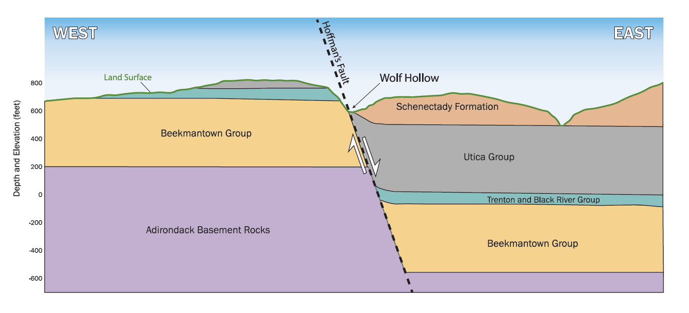
Wolf Hollow is a unique place with differing rocks and soils on either side of the road caused by a fault or slippage in the earth. (Learn more from our geology section below.) This difference in soils has created a striking difference in vegetation on each side of the trail. On the east side of the road (left side walking down) is a forest dominated by large evergreen eastern hemlocks, yellow birch, and small mountain maples. The understory is sparse with different species of ferns scattered on bare soil.On the west side (right side walking down) there is a completely different type of forest. This side is dominated by sugar maple and American basswood with scattered white ash, northern red oak, American beech, hickories, and black maple. The understory is much more diverse with many types of spring and summer wildflowers, shrubs, and ferns. Many plant species can be found along Wolf Hollow Road – try to identify them as you walk along using field guides or plant ID apps! Look for goldenrods and other wildflowers where the Chaughtanoonda Creek meanders under the road. Bring binoculars to view plants up on the slopes.
Geology Makes a Difference!
Geology significantly impacts the types of plants that can grow in a particular area. As rocks erode over time, they transform into soils with unique mineral compositions and pH levels. Shale on the east side of the road creates acidic soils favored by hemlocks and ferns. An abundance of plant species thrive in the more hospitable limestone-based soils on the west side of the road.
Wolf Hollow is a distinctive landscape feature in this region between the Catskill and Adirondack mountains. The Hollow is a deep gorge in the landscape, which was historically used as a navigation point by the Mohawk and Mohican peoples who traveled between the Mohawk River and their trapping and trade routes to the north. Although the Hollow’s walls were steep, the gentle incline of the footpath running through it offered Indigenous tribes an easy passageway. In the 1800s, European settlers discovered this well-worn footpath as a safer route for hauling limestone cut from the Glenville hills. They established a road suitable for horse-drawn wagons. Wolf Hollow remained open for vehicular traffic until 2011, when damage from Hurricane Irene forced its closure.
Wolf Hollow Road has been documented as the route Kateri Tekakwitha traveled as she fled her Mohawkvillage in present-day Auriesville in 1667. Centuries later, Kateri would become the first Native American saint of the Catholic church. Wolf Hollow alsohas historical significance as the site of one of the largest Native Americanbattles in history, the 1669 Battle of Kinquariones.
Early Conservation Efforts
After the turn of the century, Wolf Hollow Road gained immense appreciation as a place of uniquenatural beauty. As early as 1928, the local Gazette published articles from various authors advocating for theconservation of Wolf Hollow. Among these early advocates was Town of Glenville Historian Percy Van Epps, whose papers illustrated the importance of Wolf Hollow’s history and ecology.
Multiple groups, including the Town of Glenville, Schenectady County, and the Mohawk Hudson Land Conservancy (MHLC), have supported the preservation of this delicate habitatand efforts to provide safe pedestrian access to the trail. As of 2025, MHLC has protected nearly 400 acres of the surrounding lands from development. Conservation efforts in thispriority area are ongoing.
Battle of Kinquariones
One of the largest Native American battles in history took place at Wolf Hollow in the summer of 1669. The Mohawks and the Mohicans, who often fought over control of the Mohawk Valley and the opportunity to hunt and fish there, met in Wolf Hollow for two days of fighting. The encounter was named Battle of Kinquariones, after an Algonquin village in that area just west of Wolf Hollow. The Mohawks, led by Chief Kryn, won a decisive victory, securing control of the Mohawk Valley for another century before European colonization claimed the land and continued displacing Native Americans.
Photo below courtesy of the Schenectady County Historical Society.
Wolf Hollow, a geological exhibit and true marvel of natural history, is a north-northeast trending canyon. This unique formation results from a zone of weakness in the earth’s crust caused by faulting, a region where the rock is more susceptible to breaking due to geological stress. This fault was likely initiated during the Taconic Mountain Building Event (~450 million years ago) when North America collided with a string of volcanic islands to the east.
The faulting juxtaposed older, fossil-rich limestones and dolomite rocks on the west side of the Hollow against younger sandstones and shales on the east side. The rock layers east of the fault dropped relative to the west side layers, making the westerly rocks older at a given elevation. Despite the absence of recent fault activity, the legacy of Hoffman’s Fault has left a zone of weakness that was easily eroded into the cleft in the hillside, creating the landscape we see today.
Diagram below adapted from "Geology of Wolf Hollow, Schenectady County, NY" J. I. Garver, Geology Department, Union College.
The Impact of Glacial Lakes
At the end of the last Ice Age (14,000-15,000 years ago), long after faulting had ceased, the Hollow served as the outlet for the drainage of one glacial lake into another. Glacial Lake Glenville, located to the north of what is now West Glenville, drained through Wolf Hollow and into Glacial Lake Amsterdam, which occupied the portion of the eastern Mohawk Valley between Amsterdam and Scotia. Both lakes were dammed by the retreating Hudson Lobe of the Laurentide Ice Sheet, which once covered our region with more than a mile of ice.
Hoffman’s Delta, the flat fan-shaped surface that emerges southward from the mouth of Wolf Hollow, standing ~150 feet above the Mohawk River, was deposited during this interval of icy drainage of the glacial lakes. The outflow from Glacial Lake Glenville flowed down Wolf Hollow cutting the deep canyon we see today. It is a powerful reminder of the immense forces of nature that have shaped our world.
Map below adapted from "Glacial Lake Sequences in the Eastern Mohawk-Northern Hudson Region," La Fleur, Robert G., 1965. (Modifications were made to the original map to clarify location names and enhance image quality.)